Subcounty Data: Cautions and Recommendations
IECAM has early childhood service and demographic data available on the zip code, township, elementary/unit school district, Chicago Community Area (CCA), and municipality levels. But be careful; these smaller areas sometimes do not fit nicely within the boundaries of other geographic areas.
Need data for areas smaller than your county? IECAM has early childhood service and demographic data available on the zip code, township, elementary/unit school district, Chicago Community Area (CCA), and municipality levels. But be careful; these smaller areas sometimes do not fit nicely within the boundaries of other geographic areas.
Cautions
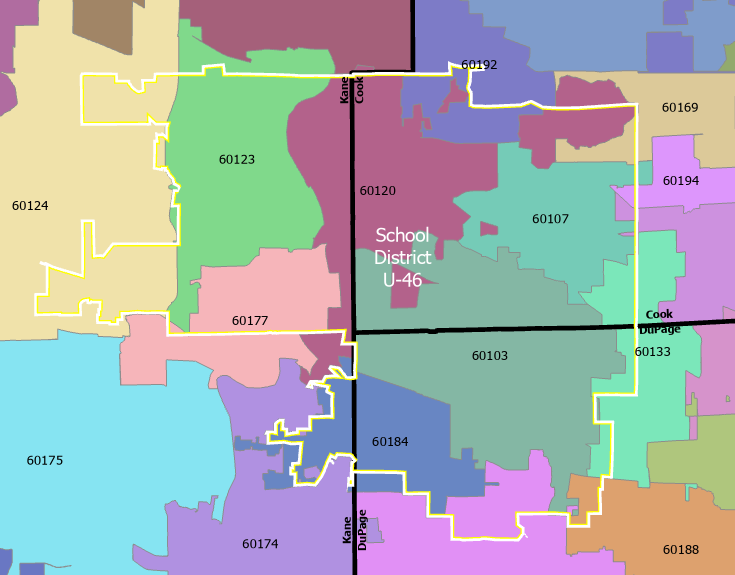
This multilayered image shows that geographic areas for school districts, zip codes, and counties, for example, often do not share boundaries. The lack of consistently common boundaries among these geographic regions, and others, can create challenges in understanding data at different scales.
Note that the Unit School District 46 (in yellow) is in three counties and encompasses parts (but not all) of more than a dozen zip codes.
Recommendations
- Need to break down your county into smaller units but stay within county boundaries? Try selecting "Township" as region when using the online database because township boundaries do not extend into neighboring counties.
- Census tracts can also be used to zoom in to the neighborhood level, and, like townships, they do not cross into another county. While the IECAM online database does not provide data on the census tract level, IECAM staff can respond to census tract data requests via our online form.